 WinSism run under Windows 32 and 64
WinSism is your Windows solutions to
process Seismic refraction. The software is user friendly and can be used very
intuitively.
With WinSism you
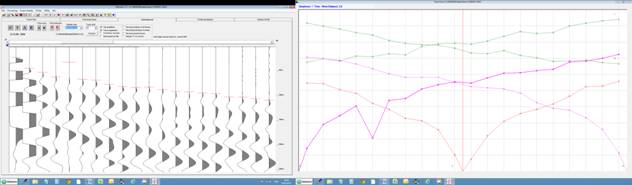
can display SEG-2, SEG-Y, ABEM, OYO, PASI and Geometrics records. first break picking is very easy and precise on the screen.
On screen corrections are possible for FBP.
After your enter field
geometry, travel time assembly takes few seconds and data can be corrected on a
build-in spreadsheet. Shots and receivers can have any geometry and elevations.
All data are recorded in an ASCII file (maximum 200 receivers and 50 shots).
The main features of WinSism are:
|
For processing ·
Trace phantoming ·
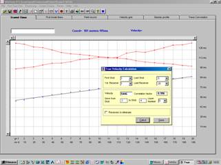
True velocity ·
Velocity computation (regression fit) ·
Velocity computation (linear) ·
Interactive FBP ·
Easy geometry input |
For computation ·
Intercept time method ·
Critical distance method ·
ABC/Delay method ·
GRM Method |
|
For display and printing ·
Travel time with precise scale ·
Preview with zooming ·
WMF export of all plots ·
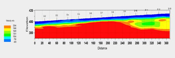
Color Seismic profile with depth ·
Computation results ·
Export to RAYFRACT, PLOTREFRA, SEISOPT ·
Field record and Travel Time display |
WinSism allows all usual operations
for refraction processing, graphically on the screen. A manual and many tags
are available. WinSism checks all data
inputs against errors. Default values are proposed. A manual with demo data,
processing explanations and used formulas is provided with WinSism. W-GeoSoft USB
key. It contains videos and PowerPoint explaining all processing steps |
.
WinSism17 comes with an inversion module TomoTEA. The initial inversion velocity grid is the
velocity grid provided by WinSism traditional processing and not arbitrary
values. The inversion use up-to-date Eikonal / Frechet algorithm
.
The processing has 4 steps:
1- WinSism will prepare and record all
necessary files: topographical data, first beaks, shots location.
2-The velocity grid must be smoothed
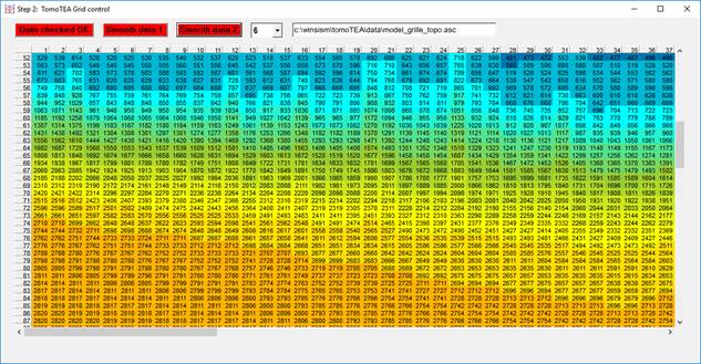
3- Last step, launch inversion process, change
default values if required.
4-Display and arrange final section (axes,
level, color scale)
No need of external software, easy to use,
quick processing
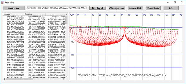
Many utilities are provided:
Ray tracing
Travel time comparison
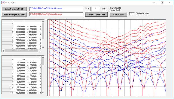
Residual times